
ឯកសារ:Ponta de São Lourenço north north east.jpg

ទំហំរបស់ការមើលមុននេះ: ៨០០ × ៣៦៦ ភីកសែ។ ភាពម៉ត់ផ្សេងទៀត៖ ៣២០ × ១៤៦ ភីកសែ | ៦៤០ × ២៩៣ ភីកសែ | ១០២៤ × ៤៦៨ ភីកសែ | ១២៨០ × ៥៨៥ ភីកសែ | ២៥៦០ × ១១៧០ ភីកសែ | ១០០០០ × ៤៥៧១ ភីកសែ។
រូបភាពដើម (១០០០០ × ៤៥៧១ ភីកសែល ទំហំឯកសារ៖ ៥.២៨មេកាបៃ ប្រភេទ MIME៖ image/jpeg)
ចំណារពន្យល់
| ការពិពណ៌នា |
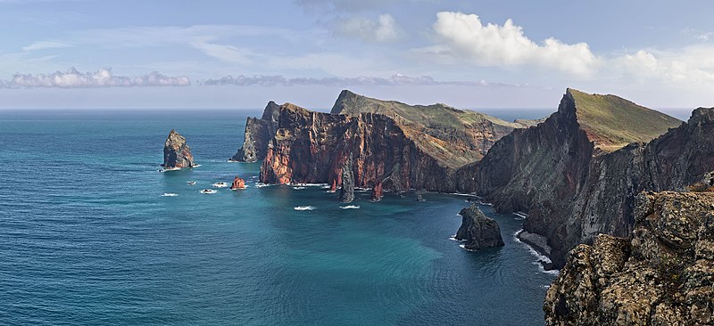
Deutsch: Ponta de São Lourenço, Madeira, Portugal. Blickrichtung Nord Nord Ost.
English: Ponta de São Lourenço, Madeira, Portugal. Heading north north east.
বাংলা: পোঁতা দে সাঁও লোরেসন্সু, মদিরা, পর্তুগাল। উত্তর উত্তর পূর্ব হতে ।
فارسی: پونتا د سائو لورنسو، جزایر مادیرا، پرتقال. این جزایر متعلق به کشور پرتقال است و در اقیانوس اطلس قرار دارد. |
| កាលបរិច្ឆេទ | |
| ប្រភព | ការងារផ្ទាល់របស់អ្នកផ្ទុកឡើង |
| អ្នកនិពន្ធ | Richard Bartz |
| ការអនុញ្ញាត (ប្រើឯកសារនេះឡើងវិញ) |
ឯកសារនេះជាប់អាជ្ញាបណ្ឌCreative Commons Attribution-Share Alike 3.0 Unported។
|
|
This image was selected as picture of the day on Wikimedia Commons for 1 March 2014. It was captioned as follows: English: Ponta de São Lourenço, Madeira, Portugal. Other languages:
Bosanski: Ponta de São Lourenço na portugalskom ostrvu Madeira. English: Ponta de São Lourenço, Madeira, Portugal. Русский: Побережье острова Мадейра в районе природного заповедника «Понта-де-Сан-Лоуренсу». বাংলা : পোঁতা দে সাঁও লোরেসন্সু, মদিরা, পর্তুগাল। উত্তর উত্তর পূর্ব হতে । 中文: 葡萄牙马德拉圣洛伦索角。 |
| ទីតាំងម៉ាស៊ីនថត | | រូបភាពនេះនិងរូបភាពផ្សេងទៀតនៅឯទីតាំងរបស់វាលើ: OpenStreetMap |
|---|

|
This image has been assessed under the valued image criteria and is considered the most valued image on Commons within the scope: Western part of Ponta de São Lourenço. You can see its nomination here. |
This image has been assessed using the Quality image guidelines and is considered a Quality image.
|
ប្រវត្តិឯកសារ
ចុចលើម៉ោងនិងកាលបរិច្ឆេទដើម្បីមើលឯកសារដែលបានផ្ទុកឡើងនៅពេលនោះ។
| ម៉ោងនិងកាលបរិច្ឆេទ | កូនរូបភាព | វិមាត្រ | អ្នកប្រើប្រាស់ | យោបល់ | |
|---|---|---|---|---|---|
| បច្ចុប្បន្ន | ម៉ោង១៣:៣៦ ថ្ងៃអាទិត្យ ទី២២ ខែធ្នូ ឆ្នាំ២០១៣ | | ១០០០០ × ៤៥៧១ (៥.២៨មេកាបៃ) | Richard Bartz | Minor fix |
| ម៉ោង១២:៣៩ ថ្ងៃអាទិត្យ ទី២២ ខែធ្នូ ឆ្នាំ២០១៣ |  | ១០០០០ × ៤៥៧១ (៥.២៨មេកាបៃ) | Richard Bartz | == {{int:filedesc}} == {{Information |Description={{mld |de=''' Ponta de São Lourenço''' Madeira, Portugal. Blickrichtung Nord Nord Ost. |en='''Ponta de São Lourenço''' Madeira, Portugal. Heading north north east. |Source = {{Own}} |Date = 2013-112... |
បម្រើបម្រាស់ឯកសារ
គ្មានទំព័រណាមួយដែលប្រើប្រាស់ឯកសារនេះទេ។
បម្រើបម្រាស់ឯកសារជាសាកល
វីគីដទៃទៀតដូចខាងក្រោមនេះប្រើប្រាស់ឯកសារនេះ៖
- ការប្រើប្រាស់នៅក្នុង be-tarask.wikipedia.org
- ការប្រើប្រាស់នៅក្នុង bn.wikipedia.org
- ការប្រើប្រាស់នៅក្នុង crh.wikipedia.org
- ការប្រើប្រាស់នៅក្នុង cv.wikipedia.org
- ការប្រើប្រាស់នៅក្នុង de.wikipedia.org
- ការប្រើប្រាស់នៅក្នុង dsb.wikipedia.org
- ការប្រើប្រាស់នៅក្នុង en.wikipedia.org
- User:Richard Bartz
- Wikipedia:Wikipedia Signpost/2014-03-05/Discussion report
- Wikipedia:Wikipedia Signpost/Single/2014-03-05
- User:JeffKobs
- User:Georgiarts
- Ponta de São Lourenço
- Frederico Cunha
- User:Morneo06
- Talk:Madeira/Archive 1
- User:BlueSentinel122/sandbox
- Wikipedia:Wikipedia Signpost/2022-05-29/Gallery
- Wikipedia:Wikipedia Signpost/Single/2022-05-29
- ការប្រើប្រាស់នៅក្នុង en.wiktionary.org
- ការប្រើប្រាស់នៅក្នុង es.wikipedia.org
- Madeira
- Isla de Madeira
- Wikipedia:Imágenes destacadas/Lugares/Europa
- Wikipedia:Recurso del día/701 - 800
- Anexo:Lugares de importancia comunitaria de Portugal
- Wikipedia:Candidatos a recursos destacados/Febrero-2015
- Wikipedia:Candidatos a recursos destacados/Ponta de São Lourenço north north east.jpg
- Wikipedia:Recurso del día/marzo de 2015
- Plantilla:RDD/756
- Wikipedia:Recurso del día/noviembre de 2015
- Wikipedia:Recurso del día/enero de 2018
- Wikipedia:Recurso del día/abril de 2020
- Wikipedia:Recurso del día/noviembre de 2022
- ការប្រើប្រាស់នៅក្នុង eu.wikipedia.org
- ការប្រើប្រាស់នៅក្នុង fa.wikipedia.org
View more global usage of this file.